• Portal UGM
    • Profil UGM
    • Pendaftaran Mahasiswa
    • Simaster
    • Akademik
    • Kemahasiswaan
    • Perpustakaan
    • IT Center
    • LPPM
  • Portal Geografi
    • Faluktas Geografi
    • Geografi Lingkungan
    • Sains Informasi Geografi
    • Geografi Pembangunan
  • Bahasa Indonesia
    • English
    • Bahasa Indonesia
Universitas Gadjah Mada Laboratorium Geomorfologi Lingkungan dan Mitigasi Bencana
Fakultas Geografi, Universitas Gadjah Mada
  • Home
  • Layanan
    • Uji Tanah
    • Penyewaan Alat
    • Praktikum Semester I
    • Praktikum Semester II
  • Pelatihan
    • Geomorfologi Longsor
    • Geomorfologi Gunung Api
    • Geomorfologi Karst
    • Geomorfologi Sumberdaya
    • Geomorfologi Kepesisiran
  • Portofolio
  • Staff
  • FORMULIR
  • Beranda
  • Penelitian
  • Penelitian
Arsip:

Penelitian

Volunteered Geographic Information Mobile Application for Participatory Landslide Inventory Mapping

Penelitian Rabu, 30 November 2022

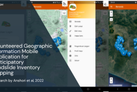
Research by Anshori et al., 2022

Participatory landslide inventory mapping using the Volunteered Geographic Information (VGI) mobile app is a promising method to produce a landslide inventory map. The aim of this research is to describe the development and implementation of the VGI mobile app for participatory landslide inventory mapping. The architecture VGI mobile app is developed on the basis of Free Open-source Software for Geospatial Application server-client software to ensure reproducibility and flexibility, and to reduce cost. Anyone can reproduce, modify, and share the code, which suggests improvement in the collective ability to use, prepare, and landslide inventory update. Landslide inventory using VGI mobile app shows that the tool and method successfully map landslides in the landslide prone area (Magelang Regency, Central Java Province, Indonesia) with fairly high levels of effectiveness and convenience. Magelang Regency, one of the landslide prone areas in Java, is located in the intermountain basin surrounded by Menoreh Mountain, Merapi, Merbabu, Suropati-Telomoyo Complex, and Sumbing Volcano. read more

Dynamics of Two Caldera-Forming Eruptions (Banda Besar and Naira) in the Marine Conservation Zone of Banda, Maluku, Indonesia

Penelitian Selasa, 29 November 2022

Research by Suhendro et al., 2022

This is the first study discussing the dynamics of two caldera-forming eruptions in the Banda volcanic complex (BVC) in the marine conservation zone of Banda, Maluku, Indonesia. The first and second caldera episodes are, hereafter, termed as Banda Besar and Naira, respectively. The formation of Banda Besar caldera (ca. 8×7 km) ejected homogeneous rhyolitic magmas (bulk-rock, 73.1–73.8 wt.% SiO2) in the following three stages: (1) sub-Plinian (BB-5a), (2) intra-sub-Plinian flow (BB-5b), and (3) caldera collapse (BB-5c and BB-5d). The BB-5a stage produced a reversely graded white pumice fall layer with moderate lithics (2–11%), which originated from a sub-Plinian eruption with an estimated plume height of 22–23 km. Subsequently, intensive erosion of wall rock (13–25%) causes conduit enlargement, leading to the partial collapse of the eruption columns, forming intrasub-Plinian flow deposits (BB-5b). It is likely that conduit size surpassed the minimum threshold value for a buoyant plume during the final phase of the second stage, causing the complete formation of a pumice-rich pyroclastic density current (PDC) during the early-third stage (BB-5c). Finally, the evacuation of voluminous magma from the reservoir yields the first caldera collapse during the late-third stage, producing a lithic-dominated PDC with minor pumices (BB-5d). read more

The Formation of an Open Atoll in Strike Slip-fault Setting: New Insight from Maratua Island, Kalimantan-Indonesia

Penelitian Selasa, 29 November 2022

Research by Haryono et al., 2022

This study aims at reconstructing the mechanism explaining the formation of the V-shaped open atoll of Maratua Island. The reconstruction was conducted by examining the landforms, lithology, and geological structure of the region. We first examined the island through ALOS, SRTM image and using an oblique aerial photograph taken using a drone. Then, a field survey was conducted to identify the detailed morphological features, lithology, and structure of the area. The results reveal that the island has developed into seven different landforms, namely, karst ridge, undulated karst hills, structural valley, marine terrace, beach, fringing reef, and sand cays. The sinistral fault system is the major factor that controlled the Maratua Island’s formation, wherein the island is a push-up morphology of the fault that formed a carbonate high. Accordingly, the atoll formation seems to be an inheritance of eroded rollover anticline of Pliocene carbonate or older and continuing to the present time. The open atoll is caused by the southern block’s downward movement resulting from an oblique subsidiary sinistral fault mechanism. The research findings unveil new mechanism of atoll formation in the strike-slip fault setting that enrich the previous models. read more

Recent Posts

  • Pengumuman Pelaksanaan Praktikum Semester Genap T.A. 2024/2025
  • Prosedur Peminjaman Alat
  • Prosedur Pelayanan Uji Sampel Tanah
  • Daftar Sewa Alat
  • Pengumuman Pelaksanaan Praktikum Manajemen Bencana Semester Gasal T.A. 2023/2024
Universitas Gadjah Mada

Laboratorium Geomorfologi Lingkungan dan Mitigasi Bencana
Gedung Klinik Lingkungan dan Mitigasi Bencana Lantai 1

Fakultas Geografi Universitas Gadjah Mada
Sekip Utara, Bulaksumur, Yogyakarta 55281
Phone (0274)6492337
Email: glmb.geo@ugm.ac.id

© Universitas Gadjah Mada

KEBIJAKAN PRIVASI/PRIVACY POLICY

[EN] We use cookies to help our viewer get the best experience on our website. -- [ID] Kami menggunakan cookie untuk membantu pengunjung kami mendapatkan pengalaman terbaik di situs web kami.I Agree / Saya Setuju