Research by Suhendro et al., 2022
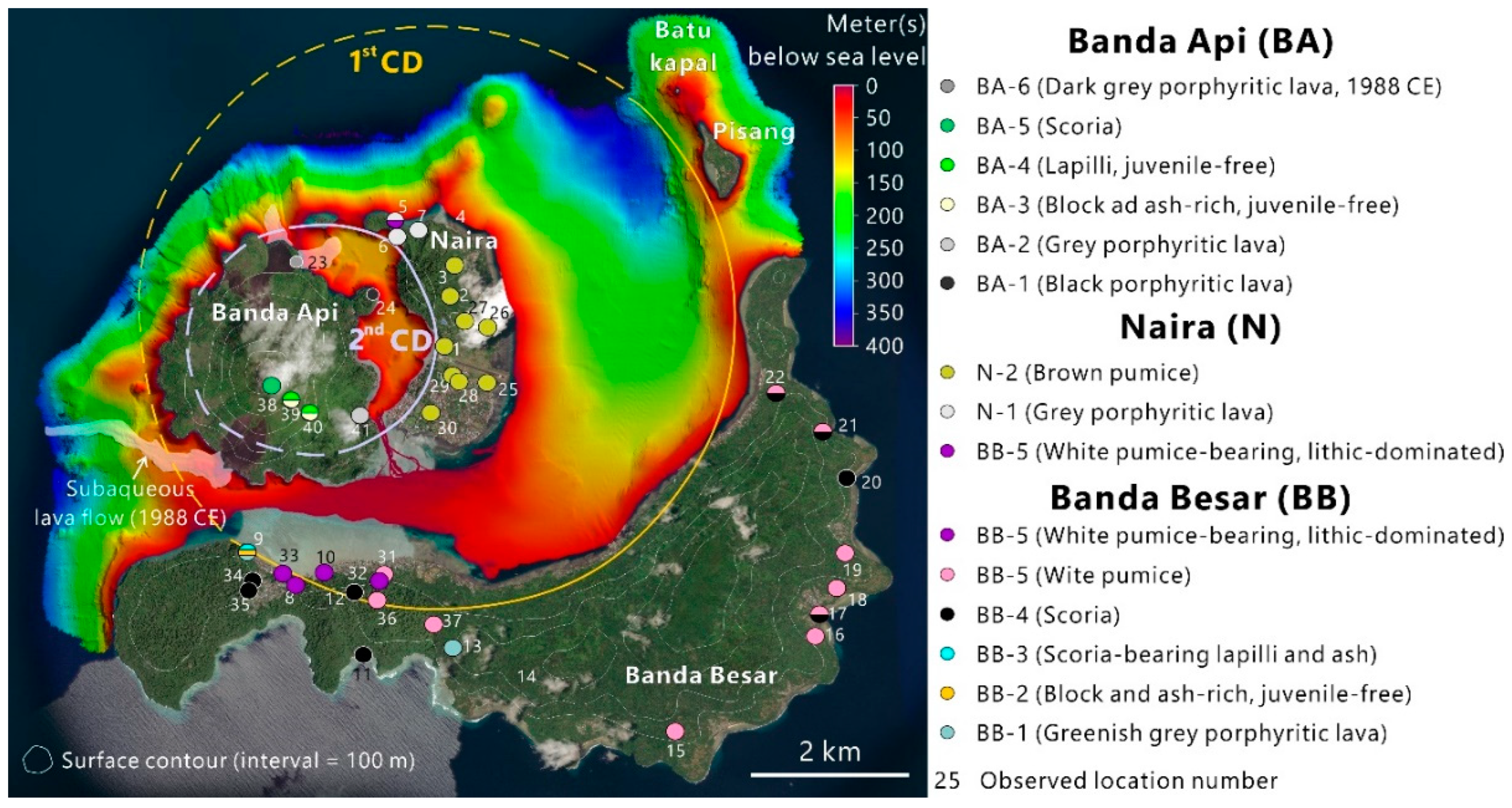
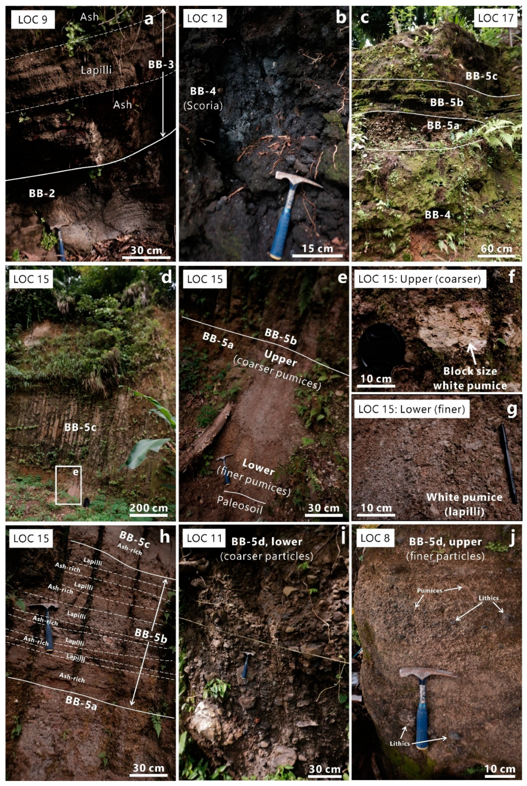
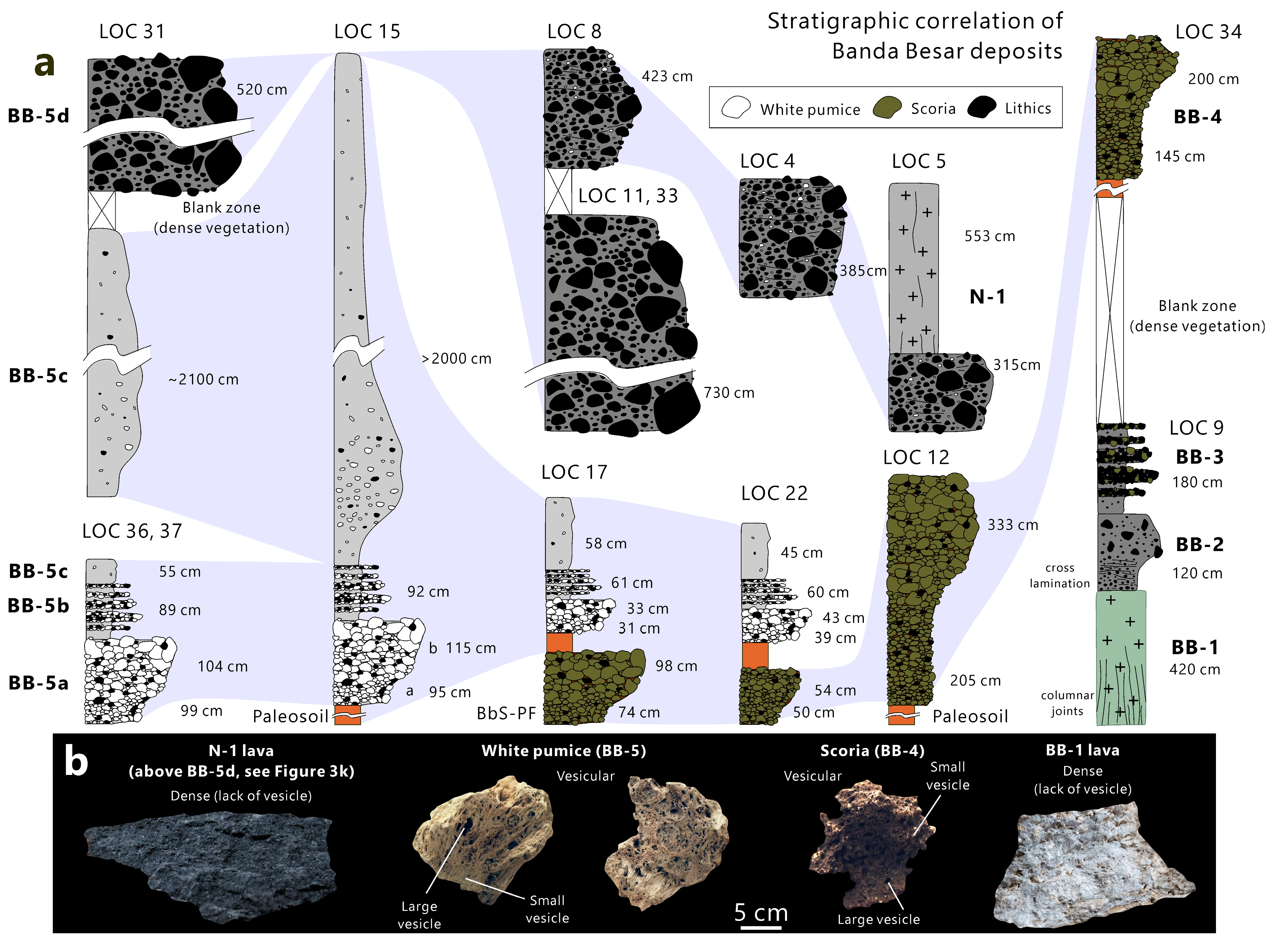
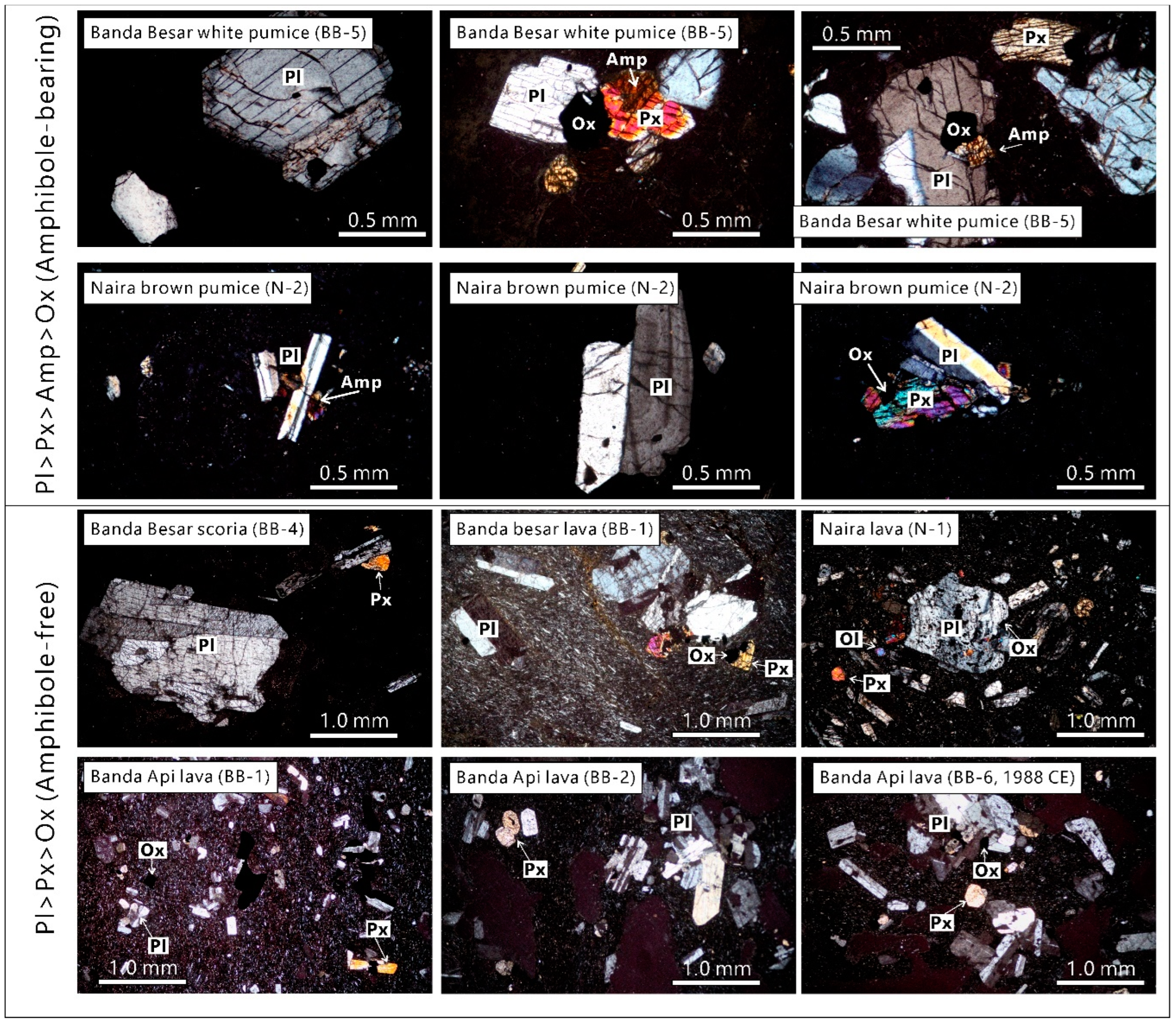
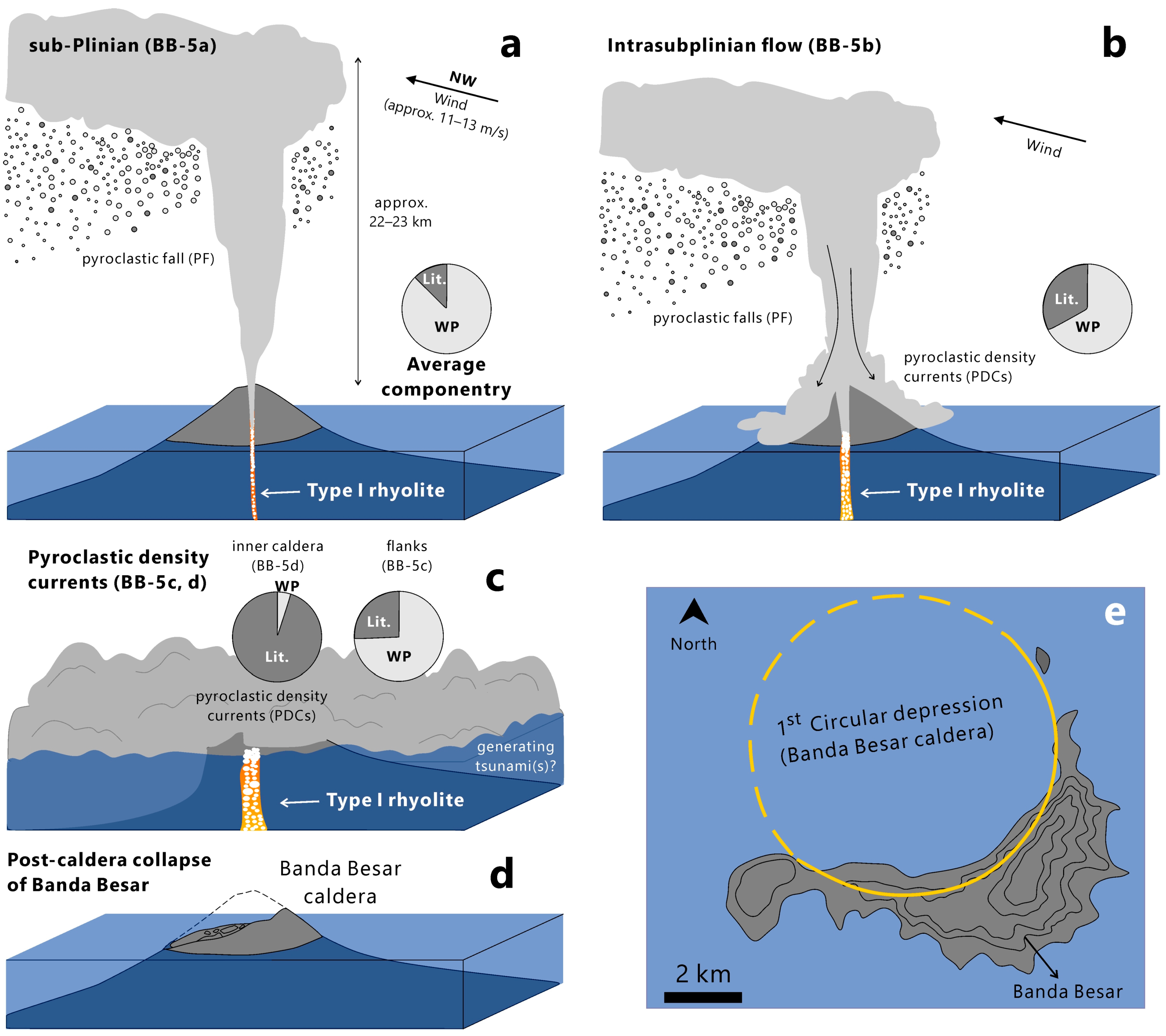
This is the first study discussing the dynamics of two caldera-forming eruptions in the Banda volcanic complex (BVC) in the marine conservation zone of Banda, Maluku, Indonesia. The first and second caldera episodes are, hereafter, termed as Banda Besar and Naira, respectively. The formation of Banda Besar caldera (ca. 8×7 km) ejected homogeneous rhyolitic magmas (bulk-rock, 73.1–73.8 wt.% SiO2) in the following three stages: (1) sub-Plinian (BB-5a), (2) intra-sub-Plinian flow (BB-5b), and (3) caldera collapse (BB-5c and BB-5d). The BB-5a stage produced a reversely graded white pumice fall layer with moderate lithics (2–11%), which originated from a sub-Plinian eruption with an estimated plume height of 22–23 km. Subsequently, intensive erosion of wall rock (13–25%) causes conduit enlargement, leading to the partial collapse of the eruption columns, forming intrasub-Plinian flow deposits (BB-5b). It is likely that conduit size surpassed the minimum threshold value for a buoyant plume during the final phase of the second stage, causing the complete formation of a pumice-rich pyroclastic density current (PDC) during the early-third stage (BB-5c). Finally, the evacuation of voluminous magma from the reservoir yields the first caldera collapse during the late-third stage, producing a lithic-dominated PDC with minor pumices (BB-5d).
The formation of the Naira caldera (ca. 3×3 km) ejected homogeneous dacitic magmas (bulk-rock, 66.2–67.2 wt.% SiO2) in the following three stages: (1) early sub-Plinian (N-2a and 2b), (2) late sub-Plinian (N-2c, 2d, 2e), and (3) caldera collapse (N-2f). This research distinguishes the sub-Plinian into two stages on the basis of different vent locations (assumed from the isopach map). In particular, this research suggests that the early sub-Plinian stage (N-2a and 2b) erupted from the northern vent, producing 14 and 8 km eruption plume heights, respectively. Additionally, the late sub-Plinian stage (N-2c, 2d, 2e) was generated from a newly-formed conduit located in the relatively southern position, producing 12–17, 9, and 6 km eruption plume heights, respectively. Conduit enlargement is expected to occur during at both sub-Plinian stages, as lithic portions are considerably high (10–72%) and ultimately generate PDCs during the third stage (caldera collapse; N-2f). Because most of the erupted materials (for both caldera-forming eruptions) are emplaced in the ocean, estimating the erupted volume becomes difficult. However, with the assumption that the caldera dimension represents the erupted volume of magma (Vmagma), and that the total erupted volume (Vtotal) is a summation of Vmagma and the now-vanished pre-caldera island (Vvanished, represented by average lithic fractions), the first and second caldera might produce (at least) 35.2 and 2.4 km3 of erupted materials, scaling them as VEI (volcano explosivity index) 6 and 5, respectively. That VEI is more than enough to initiate a secondary hazard in the form of tsunamis triggered by volcanic activities.
Keywords: Banda Naira, submarine caldera-formaning eruptions, sub-Plinian, pyroclastic density current, rhyolitic magma, dacitic magma